
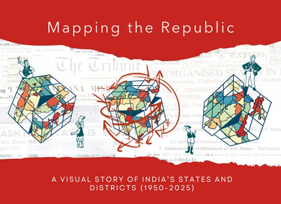
Mapping the Republic: Visual Story of India’s States and Districts 1950–2025 (Hardcover)
₹2,600.00
- By: Shivakumar Jolad, Mehr Kalra and Gaurav Kalyani
- ISBN: 9789370023925
- Price: 4000/-
- Page: 260
- Size: 11.69×8.27
- Category: History, Politics, Public Administration, Non-Fiction
- Language: English
- Delivery Time: 07-09 Days
Description
About The Book
This book is both a historical atlas and visual archive of how states and districts are formed and evolved in modern India. It addresses the lack of comprehensive tracing of India’s evolving political and administrative boundaries, post-independence. The book provides a visual narrative of how India’s states and districts came to be, how they change over time. It chronicles the transformation of India’s internal map from British provinces and Princely states in 1947 to states and Union territories and districts of today. This journey reflects how these territorial changes are shaped by linguistic and ethnic identities, along with political negotiations and developmental aspirations. The book draws from and acts as a companion piece to our work on the India State Story project website. The book utilizes maps, timelines, charts and images extensively, to illustrate India’s administrative transformation. The core of the book delves deeper into the visual timeline of each and every state and union territory, including the histories of district level transformations. Using decade-wise maps and alluvial charts, it traces the political and administrative boundary changes in each state from 1950 to 2025. It is designed with a broader audience in mind, including students, teachers, researchers, public administrators, UPSC aspirants, and general readers. Through this work, we hope to make available, easy to read and visually engaging foundational context for India’s federal and territorial structure.
About The Author
Dr. Shivakumar Jolad works as an Associate Professor of Public Policy at FLAME University, Pune, India. His research interests are social policies focused on K-12 education, migration and human development. His other interests are quantitative history of modern India focusing on Constitution , state formation and administrative evolution. Dr. Jolad’s articles have been published in the Scroll, India Forum, The Wire, ORF Briefs, Ideas for India, India Spend, Deccan Herald etc. He is the founding director of India State Stories, a visual immersive archive of India’s territorial evolution. Dr. Jolad obtained PhD in Physics and doctoral minor in Demography from The Pennsylvania State University, University Park, PA, USA.
Mehr Kalra is a Data and Regions Analyst at the WageIndicator Foundation, where she specializes in global location mapping and Living Wage data analysis. She collaborates with NGOs, global brands, and labour rights organizations to make reliable wage data both accessible and actionable. An alumna of FLAME University and holder of a Master’s in Development from Azim Premji University, Mehr also contributed to the India State Story project as a Research Associate—developing visuals and data for a pioneering initiative that traces India’s political and administrative evolution from the colonial era to the present.
Gaurav Kalyani works as a research assistant for the India State Stories project at Flame University. His work focuses on research and curation of the content for the website and associated publications. He is an early career scholar working at the intersections of history, archiving, digital humanities and public outreach. He holds a masters in archaeology from Durham University, UK. His research interests include use of digital media for communicating research to a wider audience and anti-caste history. He is also an experienced Marathi-English translator and frequently contributes on The Sathyashodhak web portal.


Reviews
There are no reviews yet.